Uses of GIS at The North Carolina Arboretum
Spatial Data and GIS in Western North Carolina |
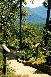
A member of the University of North Carolina System, the Arboretum spreads over 426 acres within Bent Creek Research and Experimental Forest surrounded by the Pisgah National Forest. The Arboretum serves as a regional and international resource for education, conservation and enjoyment.Ā The Plant Records department at The North Carolina Arboretum benefits from GIS by being able to monitor plant collections and provide visitors with general maps of the property.
 The use of GIS at the Arboretum is helpful in monitoring our plant collections.Ā
We can collect data on the conditions of the plants, growth rates and a variety
of other detailed areas of interest and record this information in our plant records
database program, BG Base.Ā BG Map, our mapping program works in conjunction with BG
Base to form a specialized GIS system to track our plant collections. The "BG" in BG
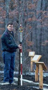
Map and BG Base stands for Botanical Garden. We map the accessioned plants at the
Arboretum as well as rockwork, trails, roads and utility lines. The non-plant features
that we put on our basemap help in locating our plants in field inventories.Ā To learn
more about BG Map and BG Base follow these links to our software provider's page.
We have recently upgraded our system to BG Map for Windows using AutoCAD Release 14.
The two programs can function separately or together as a specialized GIS. Both of the
programs are written with the same software so they work well together.
The use of GIS at the Arboretum is helpful in monitoring our plant collections.Ā
We can collect data on the conditions of the plants, growth rates and a variety
of other detailed areas of interest and record this information in our plant records
database program, BG Base.Ā BG Map, our mapping program works in conjunction with BG
Base to form a specialized GIS system to track our plant collections. The "BG" in BG
Map and BG Base stands for Botanical Garden. We map the accessioned plants at the
Arboretum as well as rockwork, trails, roads and utility lines. The non-plant features
that we put on our basemap help in locating our plants in field inventories.Ā To learn
more about BG Map and BG Base follow these links to our software provider's page.
We have recently upgraded our system to BG Map for Windows using AutoCAD Release 14.
The two programs can function separately or together as a specialized GIS. Both of the
programs are written with the same software so they work well together.
| Community Contact |
|
Angela Brown Plant Recorder & Computer Systems Specialist The North Carolina Arboretum 100 Frederick Law Olmsted Way Asheville, NC 28806-9315 |
Field Mapping |
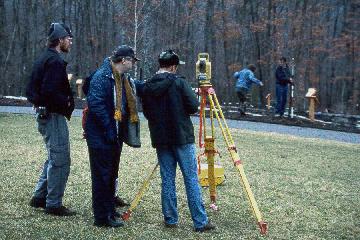 To maintain the base map, we map our gardens with a Totalstation, as seen at left.
This is a very accurate surveying instrument; we can measure with accuracy
up to 1/10 of an inch! That kind of precision is needed when you are mapping plants
that are planted in close proximity. The yellow instrument on the tripod sends a signal
to the red and white pole with the prism.
To maintain the base map, we map our gardens with a Totalstation, as seen at left.
This is a very accurate surveying instrument; we can measure with accuracy
up to 1/10 of an inch! That kind of precision is needed when you are mapping plants
that are planted in close proximity. The yellow instrument on the tripod sends a signal
to the red and white pole with the prism.
|
With this mapping equipment we are also able to record the utility line information
for our property. All of our utility lines from electric to phone lines are underground.
It is a great benefit to be able to go to a map and be able to locate utility lines.
If there is a irrigation line break we can fix the problem and know what kind of lines
that we will be seeing before we start digging.
We are hoping in the near future to be able to offer our visitors an interactive kiosk so that they can access our plant collection records and generate their own maps to take with them to find the plants on property.Ā Being able to give the public access to these records would be a great benefit and learning experience. The public would benefit from being able to take a print out of the plants that they liked at the Arboretum to their local garden centers and be able to grow them in their own landscape. Not many of our visitors know that we are taking great strides to record our plant collections and use those records for information as well as educational purposes. |
 |