GIS at Appalachian State University
Spatial Data and GIS in Western
North Carolina |
|

Geographic information systems are extremely powerful tools that give geographers,
planners, and other researchers the ability to conduct complex spatial analyses and terrain
modeling. At Appalachian State University's Department of Geography and Planning, GIS is taught
on both the graduate and undergraduate level and is utilized extensively by the Department in
several other capacities including environmental sensitivity, global change research, and
the production of state climate maps.
The Department of Geography and Planning has recently established partnerships with a number
of organizations and agencies to provide access to GIS technology. In 1997, the Department
produced the Boone Region Recreation Map and Guide for the Blue Planet Map Company, showing
hiking and biking trails, waterfalls, public lands, and many other recreational features.
Shortly after completion, this map won a third-place prize in an international map
competition sponsored by the GIS software giant, ESRI (Environmental Systems Research
Institute). In 1998, the Department completed a series of maps for the New River State
Park and the Ashe County Chamber of Commerce. The Mountain Valleys RC & D (Resource
Conservation and Development) has recently contracted our services in an environmental
sensitivity project for the Upper Broad River watershed.
 |
You may click on either image for a larger picture |
 |
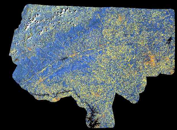
| Figure 1 |
|
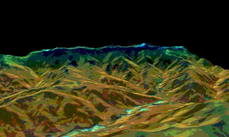
Figure 2 |
A major research project that began in 1996 is Global Change in Local Places (GCLP).
Funded by NASA, GCLP attempts to study human-induced environmental changes at the local
and regional levels to better understand the global processes. The Blue Ridge/Piedmont
Study area of North Carolina comprises 14 counties from Winston-Salem to Boone. GIS and
Image Processing have been very important tools in this research project, assisting in the
classification of land use/land cover and change detection in the study area. Figure 1
is a Landsat Thematic Mapper (TM) satellite image of the study area. Members of the Department are also using GIS in the 2nd Edition of North Carolina:
People and Environments, to be released in 1999. This textbook will include the latest
applications in GIS technology, including 3D spatial modeling of portions of WNC. Figure 2 is a digital elevation model (DEM) overlain with a TM satellite
image of the Cane River area along the western slopes of Mt. Mitchell. Using DEMs, it has
also been possible to construct climate maps that actually take topography into account,
interpolating values to better represent the spatial variability of this region's climate. The Department has also used GIS on an international level, namely in the Bolivian Andes.
Researchers used GIS to determine what percentage of the population was within a one-hour
walk of primary health care, thus measuring geographic access to health care. The research
also allowed a Bolivian non-governmental organization (which happens to be the sister
organization of the WNC-based Andean Rural Health Care) determine where to strategically
place health resources.
Teaching is the primary focus of the Department of Geography and Planning. Therefore,
we see it as essential that our undergraduate and graduate students receive superb instruction
and have access to the most current GIS hardware and software. All of our students pursuing a
GIS concentration are required to complete an internship. Many of these interns work for
agencies and local governments right here in western North Carolina (WNC), thereby providing
an important service to the region. Upon graduation, our students compete for the best GIS
jobs across the country, and many land positions with GIS software developers as well as
county planning agencies.
The Department of Geography and Planning at Appalachian State University is committed to
establishing partnerships with organizations across WNC. Paid internships for undergraduate
and graduate students, research projects, and contract work provide useful opportunities for
our students, while also serving the region. Working together, we can provide access to the
latest in GIS technology.