Landscape Ecology at Mars Hill College
Spatial Data and GIS in Western North Carolina |
What is Landscape Ecology? |
|
|
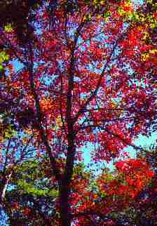
Landscape ecology studies the influence of natural spatial patterns on ecological phenomena. Spatial patterns of interest include topographic characteristics like mountain peaks and valleys, important features of wildlife habitats like food sources and nesting sites, and broader scale features such as the spatial arrangement of forest and fields in a rural landscape. The spatial arrangement of landscape features affect how ecosystems function and how their suitability varies for the species living therein. For example, a turkey hunter realizes that the best place to hunt will have both roosting trees and feeding areas in close proximity. Know it or not, the hunter is practicing landscape ecology at a rudimentary level when (s)he chooses a place that might attract turkeys. Scientists in this field use spatial data stored in geographic information systems (GIS) to study the interplay between spatial patterns and ecological processes. At Mars Hill College, GIS and spatial data are used in teaching and research related to landscape ecology topics.
GIS as a teaching tool |
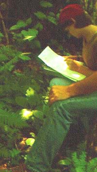
 The Biology department at Mars Hill College offers courses that deal with topics in ecology and conservation biology at introductory and advanced levels. In the introductory course students learn the importance of spatial patterns. Students in this course learn to evaluate maps of habitats and identify sites that are suitable for different species, from orchids to salamanders to migratory songbirds. More advanced students tackle more interesting and sophisticated problems. For example, they compare maps from different time periods to measure changes in the amount and spatial arrangement of forest in the Southern Blue Ridge. Activities using GIS are integrated into these courses to help students become familiar with this technology and to
provide students with a perspective on nature that is otherwise impossible to achieve. It
helps them to understand that the fine-scale phenomena happening at our feet are linked to broad-scale, landscape-level phenomena--to understand that the presence of wildflowers in farmer's woodlot depends on the movement of seeds from a nearby forest.
The Biology department at Mars Hill College offers courses that deal with topics in ecology and conservation biology at introductory and advanced levels. In the introductory course students learn the importance of spatial patterns. Students in this course learn to evaluate maps of habitats and identify sites that are suitable for different species, from orchids to salamanders to migratory songbirds. More advanced students tackle more interesting and sophisticated problems. For example, they compare maps from different time periods to measure changes in the amount and spatial arrangement of forest in the Southern Blue Ridge. Activities using GIS are integrated into these courses to help students become familiar with this technology and to
provide students with a perspective on nature that is otherwise impossible to achieve. It
helps them to understand that the fine-scale phenomena happening at our feet are linked to broad-scale, landscape-level phenomena--to understand that the presence of wildflowers in farmer's woodlot depends on the movement of seeds from a nearby forest.
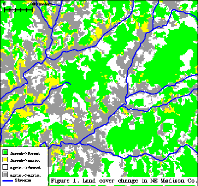
Research on Landscapes of the Southern Blue Ridge |
| Community Contact |
| Dr. Scott Pearson Mars Hill College (828) 689-1402 spearson@mhc.edu Pearson's home page |
One of ecology's major findings is that ecosystems and landscapes are dynamic! Whether slowly or quickly, they change through time in response to natural or human-related forces. Dr. Scott Pearson is one of the scientists collaborating in research on the effects of natural and human-caused changes to ecosystems in the Southern Blue Ridge mountains. This research is coordinated through the Coweeta Long-term Ecological Research Site located near Franklin NC, and includes researchers from seven different colleges and universities. More information on this program and a list of collaborating scientists can be found at the Coweeta LTER web site. Pearson's research is part of the larger, more diverse efforts of the Coweeta program. Specifically his research focused on the question, How do present and past land uses affect the numbers and kinds of plants and animals inhabiting today's forests? He is assisted by Dr. Monica Turner (Univ. of Wisconsin), Mr. Alan Smith (Mars Hill College), and Dr. Paul Bolstad (Univ. of Minnesota).
 |
Techniques used in this research are:
Findings of this research include:
Data Sources |
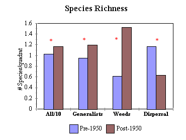 Time of forest establishment affects biodiversity of herb species |
This research relies heavily on mapping forest habitats. The spatial data needed to produce these maps come from a variety of sources. Digital maps of elevation, streams, roads, etc. were purchased from the US Geological Survey. Forest cover from different dates was derived from aerial photography and satellite images. Locations for field sampling sites are obtained from USGS 7.5 min quad maps (1:24,000 scale) and a global positioning system (GPS). GIS software is used to combine and analyze spatial data from different sources. The GIS software Geographic Resource Analysis Support System (GRASS) is used primarily for the research. Both GRASS and ArcView are used for teaching.
Click here to learn more about landscape ecology at Mars Hill College.