GIS and Planning
Spatial Data and GIS in Western
North Carolina |
|
The Division of Community Assistance |

The Division of Community Assistance (DCA), N.C. Department of Commerce,
provides aid at no cost to North Carolina’s local governments and non-profit
organizations in the areas of community development, growth management, economic
development, and public management. The Asheville DCA office has a staff of six
professional planners, a Main Street architect, a technical draftsman, and a GIS
specialist.
Geographic Information Systems (GIS) and Planning |
 Since 1989 Geographic Information Systems (GIS) technology has been integral part of the
agency’s intent to keep up with the latest technological advances in computer mapping.
The need for visual perception of problems and challenges related to planning has stood
behind the increase of popularity of GIS among local governments. GIS gives municipal
governments not only the ability to efficiently manage and store huge amounts of
geographic information, but also enables them to analyze the data and to put it in a
visual format that can be very useful in the planning process.
Since 1989 Geographic Information Systems (GIS) technology has been integral part of the
agency’s intent to keep up with the latest technological advances in computer mapping.
The need for visual perception of problems and challenges related to planning has stood
behind the increase of popularity of GIS among local governments. GIS gives municipal
governments not only the ability to efficiently manage and store huge amounts of
geographic information, but also enables them to analyze the data and to put it in a
visual format that can be very useful in the planning process.
The GIS mission of the agency is unique because it seeks to provide local governments
with a low cost opportunity to receive technical advice and support in the areas of
both planning and GIS. DCA is able to combine the expertise of its planning staff
with its limited GIS capabilities in its effort to help communities preserve their
quality of life by managing efficiently their infrastructure and planning their growth.
DCA planners have considerable experience in zoning ordinances, sign controls,
economic development, growth management techniques and and community facilitation.
GIS use by the department has backed many planning projects, whether it is analyzing
a new annexation, changing zoning, updating sewer or water line, designating priority
corridors for pedestrian use, preserving open spaces, or looking at water supply
watershed area.
GIS Capabilities and Range of Projects |
The GIS set-up at the Division includes ten PCs with Arc View licenses, a digitizing
table, and a plotter. The range of GIS assistance includes but is not limited to the
development of digital data layers and production of maps related to local planning
issues such as municipal or county zoning districts, tax parcels, utility lines, and
infrastructure. The list of projects completed in 1997 include developing digital tax
parcel and zoning layers for the towns of Marion, Highlands and
Sylva and for high growth
areas in McDowell County, utilities, parcel and infrastructure coverages for the town of
Highlands, and water supply watershed boundaries for Cherokee and Avery counties among a
variety of other projects. The digital data developed at DCA complies with the standards
set by the N.C. Geographic Information
Coordinating Council (GICC) and N.C. Center for
Geographic Information and Analysis (CGIA). The agency has developed a close relationship
with CGIA, sharing office space and equipment with its Asheville branch, and having access
to most of its digital data.
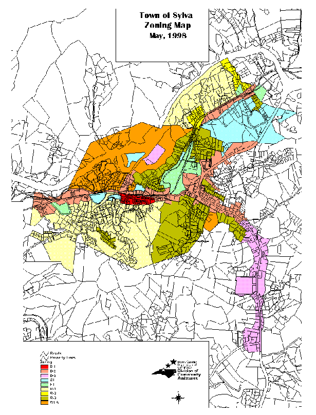
For a zoning map of the town of Sylva, Click Here.
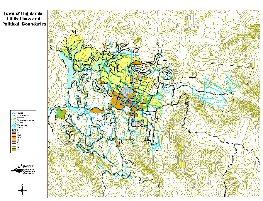
For a topography and utility lines map of Highlands, Click Here.
GIS services are provided at material recovery costs primarily to municipal
and county governments and non-profit organizations (NPOs) of Western North
Carolina's economically distressed counties. Because of its limited staff,
the office is able to assist a very limited number of clients. The focus of
attention is on communities with a very small potential of developing their
own in-house GIS services. Assistance is provided on a first-come-first-serve
basis and every project is evaluated by the
Regional Chief Planner.
The cost for GIS assistance is minimal, generally covering materials.
GIS Summer Internship at DCA |
DCA is a partner of the
North Carolina Governor's Internship Program, which
funds a ten week summer GIS internship position. The interns who successfully
pass the selection process receive GIS training, and have the opportunity to
apply their knowledge in a variety of projects developing new data layers,
editing existing ones, producing maps for presentation purposes, and providing
municipal officials with Arc View training. Internship projects that have
been successfully completed since 1996 include developing zoning, tax-parcel,
and infrastructure digital layers for the towns of Marion, Spruce Pine, and
Marshall, parcel coverage and study of Little Switzerland for the Blue Ridge
Parkway Commission, and various assignments of data update and map production.
Click here
to download an internship application form or project proposal form.
For questions about the application process contact:
Virginia Eagles, N.C. Governor's Internship Program,
Youth Advocacy and Involvement Office
217 West Jones Street, Suite 211, Raleigh, N.C. 27603 - 1336, (919) 733-9296