
PERSPECTIVE
General Rutherford's anti-Indian expedition of 2,400 men came thru the Asheville area in 1776, and one of them was a gun-toting, 'injun shootin' preacher by the name of James Hall. He seems to have been the one to name the mountain "Mount Pisgah" after the spot where Moses of the Hebrews first viewed the promised land. In any case, Mt. Pisgah is an impressive sight throughout much of the Asheville plateau, and I can't name how many car washes, laundromats, restaurants and other establishments call themselves "Pisgah View."
LOCATION
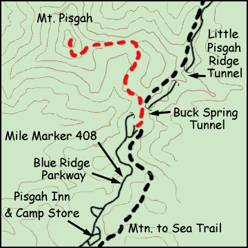
On the Blue Ridge Parkway from Asheville, headed south to around mile marker 407.7, there is an overlook and parking lot that is the trailhead for this wonderful hike. It's also a frequent spot for many photographers to record the sunset, armed with tripods, light-meters and artistic vision. In any case, right after Buck Spring Tunnel, take the first left and stay to the left to get to the trailhead. There will be a sign posting the naming of Mt. Pisgah in a little more friendly terms.
DESCRIPTION
Kinda kewl that the hike starts over the tunnel that your car just came thru, and at first the trail seems leisurely. This hike is only 1.3 miles but can get steep at times. It is not blazed, but it's pretty easy to follow the millions of footsteps before you. It can be very windy in the parking lot and remember it's going to be at least as windy up top Pisgah.
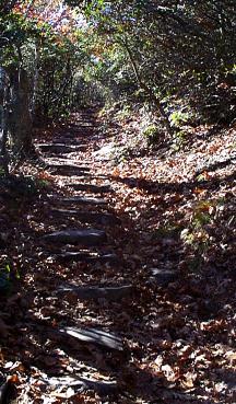
The trail is a boulder-strewn stroll thru mixed-hardwood forest of oaks and mountain laurel, rhododendrons and plenty of mosses. Soon the wind sweeping over the gap dies down and the woods opens into mostly oaks. Cinquefoil, gentians and asters line the path along with nettle, violets and the ever-present galax. At first it seems like you're not heading for Mt. Pisgah at all, but taking a beautiful stroll thru the woods. Once the path swings towards Mt. Pisgah though, the trail begins to steepen, and hikers will like the fact that the rock-strewn path has been enhanced to form almost perfect steps in the steeper areas. The rich woodland falls away behind you and you weave thru laurel and rhododendron stands punctuated by gnarlier and more stunted oaks, their bark sometimes completely obscured by lichens, drier mosses, and fungi. Several pretty yellow birch trees also stand out, and up higher, many clumps of squaw root poke out of the leaves. It gets pretty strenuous in parts here.
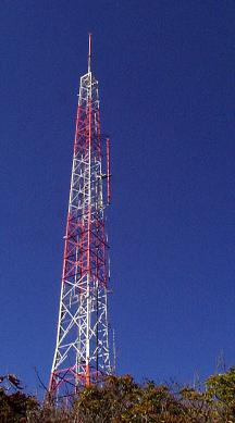
By the time you get to the main switchback, you may start to hear the wind whip up again. Crows cawing. Higher up, some high pitched singing. That's the tower, and by that time you should be able to see the orange and white missle of communications jutting out from the treeline. Here the oaks are pushed down and twisted, but still have thick trunks of old age. There's a nice stand of (yellow leaf) right near the top as you are about to pop out on the observation deck. It's windy here, and you'll be glad you didn't shed that blazer, but kept it in your backpack.
VIEW
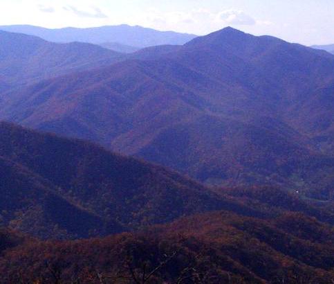
This picture above is Cold Mountain taken from the summit of Mt. Pisgah. To the left of the summit of Cold Mountain is the Shining Rock Wilderness area.
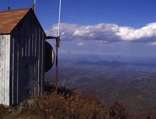
Up top Pisgah is a whole lot of communications equipment including this simple shack which has a spectacular view of the Enka-Candler area west of Asheville. I wonder if the laundromats and car-washes named "Pisgah View" know they're looking at it.
Want more information about this particular area?
Naturalist Alex Netherton has some good additional information on this hike and the hikes around the Mount Pisgah immediate area. Check them out.