
Waterfall
Hike
Waterfall
Hike
PERSPECTIVE
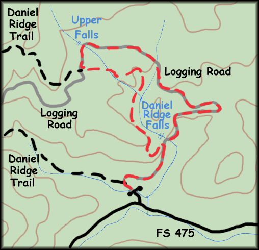
Daniel Ridge Falls is a bit misnamed because it isn't on Daniel Ridge Creek, but actually on Tom's Spring which feeds Daniel Ridge Creek. The main falls is along a logging road that's well kept (Grey in the map above), and only 3. miles from the gate. A second, and smaller, falls is up a ways, but the hike is enjoyable, and the upper falls makes a nice lunch spot. I've made a loop of the return trip by coming back Daniel Ridge Trail.
LOCATION
Off NC 276, just south of Looking Glass Falls, there's a paved FS road #475 that leads to the Fish Hatchery. The gravel road beyond this is still FS 475 and continues on. Drive about 2.4 miles of gravel road until you come to the pull-off for Daniel Ridge Trail. Park here. Follow the gravel road over the bridge, not the trail that splits off to the left just after. The bridge area is a popular 'cooling off' place during summer and there may be people here, dipping their hot feet and bodies in the rocky pools.
DESCRIPTION
This is a very popular area with locals and visitors. Biking is allowed on Daniel Ridge and if you're into that, it's a very hardy ride with strong technical descent. The lowlands pass thru a moist creek area where i've seen several varieties of Bee Balm. The logging road is well-kept and wanders nicely.
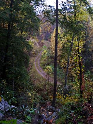
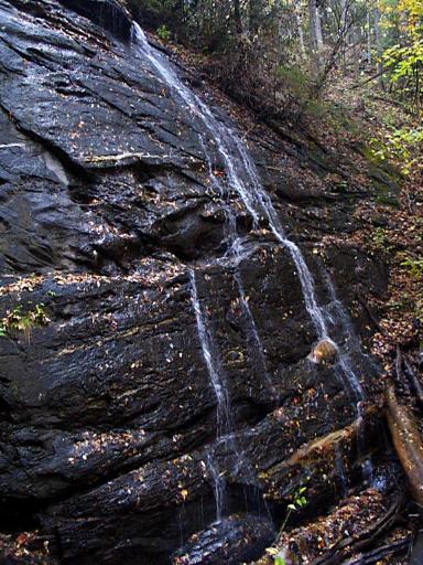
Once on the logging road you will soon be upon the 150 foot Daniel Ridge Falls (See below, under 'view'). It's not greatly impressive because it's usually not a lot of water, but scrambling around the rocks is fun and it's cool, the trail up is on the left. It is an impressive rock, either way you look at it. While you're here, go on up the logging road to a smaller falls. You are in a mixed hardwood forest with Eastern Hemlock punctuating the Oak, Maple, Yellow Poplar and others. Since you're following a road, many margin and sun-prefering plants abound here, blackberry brambles, Joe Pye Weed, Sumacs, Mullein, Asters, Smartweeds (in the moister spots) and Poke. Also saw several Macartney Roses. From the woods Blue Jays screech, Chicadees scold, and Towhees 'threep' unconcerned.
Continue on the logging road up the mountain, crossing a small branch, and then within .7 mile you will hear the upper falls on your right. This falls, while still not impressive unless very up from recent rains is a good place for a lunch or break. The path is a bit beyond the creek's crossing. It's secluded and several dusky salamanders watched me eat.
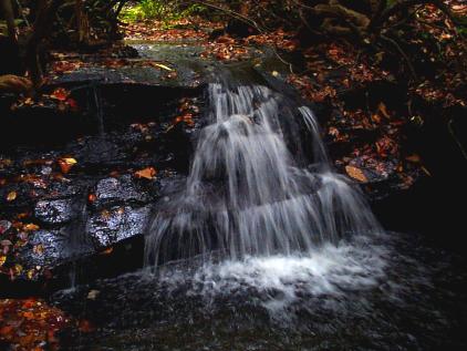
After .2 mile the road will intersect with Daniel Ridge Trail, and it's a good way back down. Almost instantly you go from sunny road to forest path, among the Mountain Laurel and Rhododendron thickets towered over by Oaks and Maple. Rattlesnake plantain and Heartleaf Ginger dot the sides and tons of mosses line the path. Along the way are several old fields that deserve some investigation with Winged Sumac and Strawberry bushes. After a bit you'll be crossing and recrossing Tom's Spring, mostly via logs and planks as part of the trail maintenance. Good thing, because it can get muddy even away from the bank. Little falls abound, such as this one:
You'll hear the big falls you first came to before you see it. As a matter of fact, you'll be at the very top of the falls, but the area is muddy and steep so if you want to investigate, watch your footing. The path then turns away from the creek and descends back to the road, with one switchback. If the way down seems a bit too straight, a bit too man-made, it's because it is. This area when heavily logged had some sort of locomotive or steam engine hauling device, and if you'll notice on your way down, you may find bits of coal and part of a large cable.
VIEW
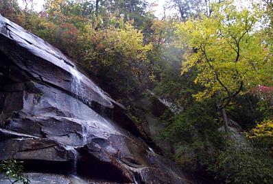
This picture was taken in fall, and there wasn't much water. The falls can be much nicer, but still not very photogenic (for lack of a good place to take the picture without natural clutter).